CARLETON COUNTY
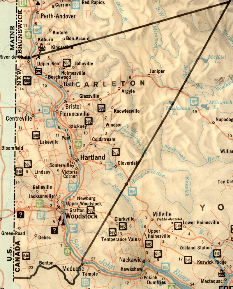
Carleton County, straddling the St. John River in western New Brunswick, contains about 1,300 square miles (832,000 acres), and is bounded on the north by Victoria County; on the east and south by York County, and on the west by the State of Maine.
The shifting geography of the County, and the Province, can complicate serious research, both historical and genealogical, frustrate the researcher, and, occasionally, result in erroneous conclusions. For example, residents in the eastern part of the Parish of Wakefield, in 1830, became residents of the Parish of Brighton by the stroke of a pen. This attempt to explore and detail the geographical evolution of the area that became Carleton County may alleviate some of the problems.
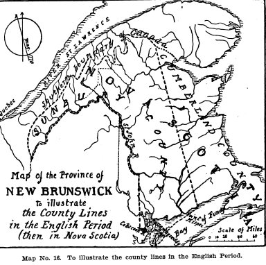
Prior to the termination of the American Revolution, the northern boundary of Nova Scotia extended to the border of Lower Canada (Quebec). In 1759, by an act of the Legislature, the province of Nova Scotia was divided into five counties, Annapolis, King’s, Cumberland, Lunenburg and Halifax — Cumberland County, “to consist of all the lands in the province of Nova Scotia lying north of King’s County,”1 thus including the entire area that later became the province of New Brunswick, as illustrated by the map at left.2
Settlement of the township of Sackville, by families from Rhode Island and Massachusetts, began about 1761; Cumberland township was settled about the same time, and Davidson and Court settled on the Miramichi in 1764. In the western part of the area, the first English settlement of the St. John River area began in 1762, and the first permanent settler in the Passamaquoddy district was Alexander Hodges in 1763. The division of Cumberland County was effected on 30 April, 1765 when Sunbury County was created, although the boundary between Sunbury and Cumberland was not defined until 24 May, 1770.
The early land grants were issued under the Great Seal of the Province of Nova Scotia, a practice that continued after the arrival of the Loyalists, until New Brunswick was established as a separate Province by order of the King in Council on 18 June, 1784. After the formation of New Brunswick, an Act3 was passed in the New Brunswick Legislative Assembly requiring the holders of these old grants to re-register them in New Brunswick within one year, or the grant would become void.
Although the first Governor of New Brunswick, Col. Thomas Carleton, arrived in New Brunswick on 21 November, 1784, and began work with his appointed Council on the following day, it was not until the year following that attention was given to the creation of counties within the Province.
On 18 May, 1785, the first County, St. John, was created; the second, Westmorland, on the next day, followed by Charlotte, as the third County, on 4 June, 1785. On 10 June, Northumberland was added. Governor Carleton wrote the Secretary of State on 28 June, 1785, stating, “The province will soon be divided into eight counties, three along the Bay of Fundy, four up the St. John River, and one at Miramichi.”4
The fifth County, Kings, was created on 4 July, 1785, followed by Queens County later that month. York County came into being on 25 July, and Sunbury, the eighth of the original counties, was created on 26 July, 1785. These counties, all created by Letters Patent, were confirmed by the very first Act5 passed at the first sitting of the new New Brunswick Legislature, held at Saint John, beginning 3 January, 1786.
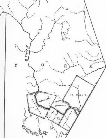
One of the “four up the St. John River” was York County with its seven original Parishes (also called “Towns” in the Act): Fredericton, Kingsclear, Prince William, Queensbury, St. Mary’s, Northampton and Woodstock, as shown at left. This map is a subset of one drawn by Dr. W. F. Ganong.6 A slightly reduced image of the full map is here.
Note the area that became the Parish of Canterbury, York County, in 1855, was then included in Woodstock Parish, and the Parish of Southampton was part of the Parish of Northampton until 1833.
Although the county of York extended from the upper boundary of Charlotte County to the border of Lower Canada (Quebec), the parishes then created encompassed only a small portion of that area, the greater part being unassigned and unsettled wilderness land.
The St. John River constituted a major part of the communications route between Halifax and Quebec, thus it was of great military importance to secure as much of that route as possible by settling the disbanded soldiers of the various Provincial regiments along the river.
Expansion of existing settlements and establishment of new settlements eventually resulted in the creation of new counties and parishes, often with severe alterations to existing boundary lines.
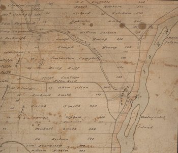
In the heavily forested and virtually trackless wilderness, the rivers were the means by which supplies, equipment and material could be transported, and access to the rivers was essential to the settlers. The first surveyed lots of land were laid out with river frontage. That frontage was as little in width as 16 rods (264 feet), which meant that a grant of 100 acres to a single man was 264 feet in width but over 3 miles in length. Married men and officers fared little better. The narrow lots did make for relatively close neighbours, desirable from the standpoint of mutual protection and defence, but seriously hampered agriculture, on which the small communities largely depended for their existence. Some of the grantees of these narrow lots either sold their grants or abandoned them, while others never set foot on their lands. Rev. W. O. Raymond, in his newspaper column, “The First English Proprietors of the Parish of Woodstock,” published in the Woodstock Dispatch, 31 July, 1895, tabulates the original deLancey grantees of Woodstock, each with their allotted acres, and the later amalgamation of the smaller lots.
The town or parish constituted the smallest component of provincial government. While courts, gaols, and registry offices were established at the shire town of each county, the legislature recognized the need for oversight and regulation of various functions at the parish level. Accordingly, an Act7 was passed in 1786 directing the Justices of the General Sessions in each county to make appointment of “fit persons” to various offices in each parish. The number of appointees was specified for some positions, while others were left to the discretion and judgment of the Justices. Refusal of an appointment was punishable by a fine of 40 shillings.
This nascent “Civil Service” included some interesting occupations, most of which have long ago vanished:
3 Overseers of the Poor
1 Clerk of the Town or Parish
2 Constables
2 Fence Viewers
1 Clerk of the Market
Pound Keeper(s)
Cullers and Surveyors of Fish
Surveyors of Lumber and Cord Wood
1 Sealer of Leather
Gaugers of Casks
Hog Reeves
3 Assessors of Rates and Taxes
Surveyors and Weighers of Hay
Inspectors and Examiners of any staple commodity for market
The initial settlements in the area that became Carleton County remained relatively static for a number of years, although there was some migration of both Loyalist and pre-Loyalists from the southern part of the Province. Exact dates of establishment of new settlements is often unknown, so reliance must rest heavily on Dr. Ganong’s notes.8
William Orser, a Loyalist from New York, settled at the mouth of the Becaquimac, on the site of an old Indian village, around 1790, and in 1791, a military post was established on the opposite side of the St. John River, at the mouth of the Presquile stream. During the late 1790s and early 1800s, other settlers from Maugerville and the lower part of the St. John River migrated to the area that was established as the Parish of Wakefield in 1803.9 This newly created York County parish spanned the St. John River, being bounded on the south by the old parishes of Woodstock and Northampton.
Settlement gained momentum in the early 1800s, progressing up both sides of the St. John river, mainly by migration from the lower St. John river counties. On 26 January, 1803, Rev. Frederick Dibblee reported10 the population of the Parish of Woodstock (then including the Parish of Canterbury) as 87 men, 76 women, 82 children over ten years of age, and 143 under age ten, a total of 388.
Rev. Dibblee also wrote that the population of the Parish of Northampton11, which included Southampton at that time, consisted of 61 men, 53 women, 113 children over age ten and 101 children under ten years of age, for a total of 328.
On May 19th in that year, Lieut. Arthur Nicholson reported12 on the “State of Population in the District next above the Parishes of Woodstock and Northampton, extending to the River De Chute,” stating there was a population of 214 — 55 men, 43 women, 37 children above age ten and 79 younger children. In addition, his report provided the names of the heads of household.
(By 1824, York, with a population of 10,972, was the third most populous County in New Brunswick. The population of Woodstock Parish had more than doubled, to 816, while Northampton had grown to 568. But Wakefield Parish had enjoyed tremendous growth — the population had increased nearly fivefold, to 1,010.13)
In his 1803 reports, Rev. Dibblee made particular mention of the vacant land between Woodstock and the American border, praising the superior quality of the land, and stating, “There are not less than thirty who have it in contemplation to settle there if they can meet with encouragement from Government.” Evidently Government “encouragement” was not immediately forthcoming, for no attempt at settlement was made in that area until 1814, despite Reverend Dibblee’s laudatory remarks.
During the Revolutionary war dispatches had been constantly carried between Halifax and Quebec by way of the river St. John. At the termination of the war the governors of Quebec and Nova Scotia were determined to establish a better means of communication. In 1783, General Haldimand wrote Governor Parr that he intended to open up a road between the two provinces, and accordingly had employed surveyors to lay out a road from Kamouraska across the portage to lake Temiscouta and 200 men were then at work upon it. It was his intention to establish a good man at Lake Temiscouta with canoes which would supply the means for crossing that lake and proceeding down the Madawaska and the river St. John to Aukpaque at the head of the settlements on the river.
General Haldimand engaged Captain John Munro, a Loyalist from Albany, New York, who had served in the 1st Battalion, K.R.R.N.Y., to “proceed to Halifax by the Temiscouta road, and make observations in writing to its condition, difficulties, improvements wanted, etc., and submit them to Governor Parr.” His “Remarks in regard to the new road to Lake Timisguata,” (published by Douglas Brymner in the Canadian Archives, 1791) speaks of “impenetrable thickets of trees and underwood,” of the necessity of “leading the road about hills and mountains to prevent great ascents and descents,” and of “carrying log roads in a straight line so that carts meeting can see one another and wait at places made on purpose wide enough for two carts to pass.” “The road in general was rocky and therefore the watery parts not so deep as what they call to swamp a horse or man.”
In 1816 the New Brunswick government expended about $12,000 upon the road “leading from Fredericton towards the Canada line.” A lengthy and particular report of the progress made and the difficulties encountered was submitted at the next session of the legislature. The report stated that the building of a bridge over the large stream “Maduxwawick” would be “attended with great expense.”
Despite recommendations, representations and petitions to the House of Assembly, the provincial government took no action until 1825 when it authorized a grant of £100 toward the construction of a bridge over the Meduxnakeag. In the meantime, the residents of the area had raised a subscription of £140 and work on a wooden bridge had commenced, using a number of Irish immigrant labourers.14
The journals of the House of Assembly for Feb. 16, 1827, record that, “Mr. Slason presented a petition from Richard Ketchum and Thomas Phillips of Woodstock in the county of York, praying that the sum of £100 granted in the year 1825 for finishing and securing the Maduxnikeek bridge be reappropriated them, they having completed the said bridge.” The grant was finally made.
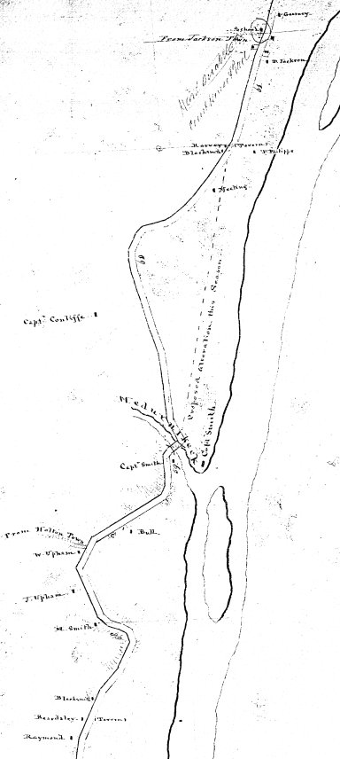
The Meduxnakeag bridge was a great benefit to the community, particularly to those on the north side of the creek, the residents of Upper Woodstock and beyond. For instance, the only physician, Dr. Samuel Rice, resided south of the creek, and the Anglican, Roman Catholic and Methodist churches were similarly situated. The bridge also hastened the travels of both civilian and military users of the Great Road to Canada by eliminating the need for two ferry crossings over the St. John River.
While English settlement continued its advance up the St. John River between 1800 and 1810 into the area that later became Peel parish, and into the future parish of Wicklow from 1803 to 1815, reaching north to Summerfield in 1807, these advances in settlement still closely followed the river. It appears that the 1810 opening of the Jacksontown-Jacksonville region by John Jackson was the earliest expansion into the back lands.
About this same time, settlers from the lower St. John River districts moved into that portion of Wakefield, east of the River, that ultimately became Brighton parish, while disbanded soldiers from the 104th Regiment and the New Brunswick Fencibles in 1817 joined the earlier migrants from the lower St. John in the region that became the parish of Kent.
Despite Rev. Dibblee’s glowing report of the district west of Woodstock, the area apparently remained unpopulated until 1814, when Samuel Parks, from Amity, Maine, settled at Parks Hill. He seems to have acquired a neighbour only in 1816 when Isaac Smith, of Saint John, established residence some three miles east of present Richmond Corner.
Subsequently, other settlements were established west of the St. John river: Benton, settled after 1816 as Rankin’s Mills; Irish Settlement, settled in 1819 by immigrants from Ireland, and Irish immigrants opened the Newburg area in the following year. Also in that same year, 1820, Irish immigrants and native settlers established Plymouth.
Although settlement had proceeded up the west side of the St. John River, following the route of the Great Road to Canada, it appears to have stalled on the east side after William Orser settled at the Becaquimac, yet when the Parish of Kent was established in 1821, it included land on both sides of the river.
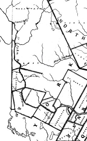
While the eastern boundary of Northumberland County was established by an Act (Cap. IV.) of the Legislature passed on 16th March, 1803, the line was not surveyed and marked until 1837. The 1803 Act that established the Parish of Wakefield, above the parishes of Woodstock and Northampton, established the northern boundary of the parish, but made no mention of an eastern boundary.
By the Act of 1821, Kent Parish was created to include “all that part of the County of York lying above the Parish of Wakefield, on both sides of the River Saint John.” Again, the eastern boundary of the parish was not specified.
No great accuracy is claimed for the map at left, a highly modified subset of one drawn by Dr. W. F. Ganong circa 1900, but it does serve to illustrate the York County parishes of interest in 1821. The section of Wakefield Parish on the east side of the St. John River became Brighton Parish by an Act (Cap. VI.) passed on 8 March, 1830.
The 1824 Census of York County shows Kent Parish with the greatest population, 2,297 people. Fredericton Parish was in second place with 1,849, followed by Douglas, 1,367; Wakefield, 1,010; St. Marys, 972; Kingsclear, 832; Woodstock, 816; Queensbury, 716; Northampton, 568, and Prince William with 545 — a total of 10,972 for the County, placing it third behind Northumberland and St. John.
Kent Parish then encompassed the Madawaska settlement, which included land transferred to the United States by the Ashburton Treaty in 1842.
Emigration from Scotland brought settlers who established McKenzie Corner and Scotch Corner (now Richmond Corner) in 1822. Andrew Currie removed from Saint John to North Richmond the following year, and Dow Settlement was formed before 1824 by expansion from existing settlements on the St. John River. Debec, a lumbering village, commenced about 1825. All these settlements were on the west side of the River.
On the east side, Rockland was settled around 1825; Coldstream was formed circa 1826, and Greenfield, about 1827. These were all created by expansion of older settlements along the St. John.
Immigrants from the north of Ireland established Watson Settlement in 1828 or 1829, while further expansion of older settlements after 1830 opened Florenceville, then named Buttermilk Creek, and the general area that became the parish of Wilmot.
The great extent of York County created a variety of administrative problems. As early as 1821, Peter Fraser, M.P.P., presented a petition from residents in the upper region, praying that the County might be divided. Two years later, a second petition from residents of Kent, Northampton, Wakefield and Woodstock parishes was presented by Jedediah Slason, another York County M.P.P. Mr. Slason moved for permission to bring in a bill to erect the those parishes into a separate county, but his motion was rejected. John Allen, M.P.P., presented a similar petition in 1826, and a bill brought in by Mr. Allen to that effect actually received first and second reading before its demise.
Subsequent attempts fared no better, but finally, in 1831, an Act was passed creating Carleton County, extending from Eel River to the boundary of Lower Canada. This Act15 did not become law until it was confirmed by the King in Council on 30 May, 1832, and was proclaimed in New Brunswick on 19 September, 1832.
The new county, and particularly the Parish of Kent, still included a vast territory, but the Legislature took some corrective action in 1833. In March of that year, the portions of the parishes of Woodstock and Northampton that remained in parent York County were renamed16 Dumfries and Southampton, respectively.
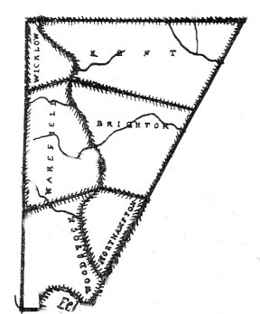
In that same month, the Legislature, recognizing the Parish of Kent, in the County of Carleton is so extensive and populous as to render the performance of the duties of the Parish officers therein inconvenient and burthensome, passed another Act dividing Kent Parish into five parts, creating the parishes of Wicklow, Perth, Andover and Madawaska, thereby redefining the boundaries of Kent, as illustrated by the map at right.
In 1832, a Saint John weekly newspaper, the New Brunswick Courier, published a series of columns in which a traveller from Fredericton described the geography, industry and settlements in the great area then embraced by Carleton County. The “Letter From Fredericton” is lengthy, but for the benefit of those interested, a transcription is, with permission, available here.
The county boundary remained in that state until 1864 when it (as well as the upper boundary of Kent parish) was returned to the 1844 line. Perhaps the county boundary survey of 1863, or complaints from owners of the divided land grants, or even the creation of Aberdeen Parish in 1863, were factors in the decision to restore the boundary.
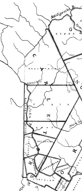
The Act defined the northern boundary of Kent Parish by a line running due east from the said river Saint John, . . . . . nearly opposite to the mouth of the river de Chute. When Victoria County was created in 1844 from the upper lands of Carleton, the boundary line separating the two counties was established as it exists today. However, for reasons presently unknown, in 1854 that boundary reverted to the upper boundary of Kent parish set forth in 1833, as shown by the map at left. This action left some of the 1826 land grants in the area in the peculiar position of having part in Carleton County while the other portion reposed in Victoria.
Perhaps it should be mentioned here that those settlers who received grants of land in 1826 above River de Chute, then in the Parish of Kent and County of Carleton, found themselves, in 1833, inhabiting the Parish of Andover, but still in Carleton County. Subsequently, in 1844, they became residents of Victoria County.
Although the area had now achieved status as a separate county, with all its contained land assigned to the individual parishes, there remained vast tracts of unsettled wilderness land in the areas distant from the River St. John. Both emigrants and migrants from other settled areas in New Brunswick were attracted to many of these locations, their travels facilitated by continued improvements to the Great Road to Canada and the navigation of the river.
The Road to Canada was of tremendous importance even before New Brunswick was created, and the New Brunswick government regarded it as one of the “Great Roads of Communication” in the province. As an aside, the other Great Roads of Communication included the road from Fredericton to Westmorland; the road from Saint John to the head of Belleisle; the road from Fredericton to St. Andrews; the road from Fredericton to the Restigouche River; the road from Saint John to St. Andrews; the road from Saint John to Westmorland; the road from the Bend of the Petitcodiac River to Shediac, and the road from Dorchester to Chatham.
In 1836, the road from Houlton, Maine, leading to Woodstock through the Richmond settlement, was added to the list of Great Roads of Communication by an Act of the Legislature.17
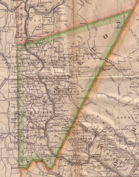
In 1834, two Irish immigrants made the initial settlement at Kilmarnock, in Northampton parish, and George Ivey, from Plymouth, England, settled Ivey’s Corner (a location that was included in Richmond parish when it was established) about the same time. Windsor, in Brighton parish, was settled at an unknown date before 1840, and Blowdown Settlement was established by migrants from the Keswick area around 1840. Emigrants from the State of Maine moved into Union Corner by 1840, or shortly thereafter, while Williamstown was settled around the same time by migration from the settled areas on the lower St. John River.
W. F. Ganong18 stated that Maxwell, on Eel River, was settled in 1842, “by an association of mechanics from Saint John under the auspices of Dr. Gesner.” He adds that Maxwell “apparently includes the present Monument Settlement, Dinnen’s Mills and Kirkland.” Gesner19 noted that “from the distress that prevailed at St. John in the winter of 1841, in consequence of destructive fires and a sudden prostration of business, twenty tradesmen and labourers, most of whom were penniless, encouraged by the benevolence of Sir William Colebrooke, the Lieutenant-Governor, embarked for Eel River.”
1842 also saw the creation of the Parish of Simonds from land in the upper part of the parish of Wakefield. In 1843, Goods Corner was settled by three brothers of that name, probably Charles, James and Solomon. The 1912 map at right shows some of these small settlements, as well as others whose dates of settlement are presently unknown. Many of the smaller places no longer appear on New Brunswick maps and some now exist only in local memory.
As mentioned above, Victoria County was established in 1844, taking the parishes of Perth, Andover and Madawaska from Carleton County. While the boundary line between Carleton and Victoria fluctuated between 1844 and 1864, as documented previously, no further alterations took place within Carleton County until the Parish of Richmond was created from the western part of Woodstock parish in 1853.
Carleton County was the first county in New Brunswick to adopt municipal government. The first election for County Councillors took place on 4 May, 1852, and at the first meeting of the Council, held in the old Court House at Upper Woodstock on May 20th, Samuel Dickinson of Brighton parish was elected the first Warden of the County. Ken Homer’s The Carleton County Council narrates the history of the Council at some length, from its inception to its demise on 16 December, 1966.
Centreville, originally called Perkins Corner, was founded circa 1855 by migration from Kings County and the Maugerville area, while Oak Mountain and Speerville were settled at about the same period by expansion from Nova Scotia settlements. Nova Scotia also contributed families from the Yarmouth area who settled Knowlesville in 1860, under the auspices of the Reverend Charles Knowles, a Free Christian Baptist minister of Yarmouth.
In 1859, the Parish of Peel was set off from Brighton parish, but representatives from Peel were only elected to the County Council in 1860, when Charles Boyd and Delancey Tompkins were seated.
Between 1860 and 1861, some 30 families from Aberdeen, Scotland, settled Glassville, under the auspices of Rev. Charles Gordon Glass, a Presbyterian minister who was also instrumental in the creation of the Woodstock College. Foreston seems to have been established some time thereafter, by expansion of the Glassville settlement. This area was included in the Parish of Aberdeen when it was created in 1863 from Kent parish, with the inclusion of a small section of land from Brighton parish. As with Peel parish, Aberdeen only gained representation on the County Council in the following year.
Johnville, in the Parish of Kent, was established in 1862 under the Labour Act, and settled by Roman Catholic families from Charlotte and St. John counties. About 1864, residents of the United States, fleeing the Civil War draft, settled at Skedaddle Ridge in Brighton Parish.
The eleventh, and last, parish to be created, Wilmot, was set off from Simonds parish in 1867 according to Dr, Ganong,20 but Rev. W. O. Raymond stated it was established two years later, in 1869.21 It appears the Parish of Wilmot was first represented on the County Council in 1870, which supports Raymond’s statement. In addition, records of the County Council for January, 1869, mention a petition from some residents of the Parish of Simonds to the Legislature, asking that the Parish be divided. The Council recommended “the prayer of the petition.”
Newburg Junction (not to be confused with Newburg) was established in 1873 when the Woodstock branch line was constructed to connect with the N.B. & Canada railway. Dr. Ganong noted that it was “originally several miles further east.” Cloverdale, also in Brighton Parish, was formed under the Free Grants Act around 1878 by expansion from the older settlements. Chapmanville, in Kent Parish, was settled in 1880 by expansion from Johnville.
It will be apparent to any one familiar with the communities in Carleton County, or to those who have pored over the various maps of the County, that the creation dates for many of the villages and hamlets are missing — those data are not presently available.
1. Murdoch, Beamish, A History of Nova-Scotia or Acadie, Vol. II., pp. 373-4, pub. James Barnes, Halifax, 1866.
2. Ganong, William F., Ph.D., A Monograph of the Evolution of the Boundaries of the Province of New Brunswick, p. 227, “Transactions of the Royal Society of Canada,” Second Series, 1901-1902, Vol. VII., Sec. II.
3. 26 Geo. III, CAP. 1, An Act for Registering of Letters Patent and Grants made under the Great Seal of the Province of Nova-Scotia, of Lands now situate within the limits of this Province.
4. Ganong, William F., Ph.D., A Monograph of the Evolution of the Boundaries of the Province of New Brunswick, p. 417, “Transactions of the Royal Society of Canada,” Second Series, 1901-1902, Vol. VII., Sec. II.
5. 26 Geo. III, CAP. 1, An Act for the better ascertaining and confirming the Boundaries of the Several Counties within this Province, and for subdividing them into Towns and Parishes.
6. Ganong, William F., Ph.D., A Monograph of the Evolution of the Boundaries of the Province of New Brunswick, insert, pp. 414-5, “Transactions of the Royal Society of Canada,” Second Series, 1901-1902, Vol. VII., Sec. II.
7. 26 Geo. III. CAP. 28, An Act for the appointment of Town or Parish Officers, in the several Counties in this Province.
8. Ganong, William F., Ph.D., A Monograph of the Evolution of the Boundaries of the Province of New Brunswick, “Transactions of the Royal Society of Canada,” Second Series, 1901-1902, Vol. VII., Sec. II., and A Monograph of the Origins of the Settlements in New Brunswick, “Transactions of the Royal Society of Canada,” Second Series, 1904-1905, Vol. X., Sect. II.
9. 43 Geo. III. CAP 5, An ACT for erecting the upper part of the County of York into a distinct Town and Parish.
10. Raymond, W. O., Winslow Papers, p. 484.
11. Ibid, p. 485.
12. Ibid, pp. 485-6.
13. Fisher, Peter, Sketches of New Brunswick, 1825, Saint John, 1921 reprint, p. 90.
14. Raymond, W. O., “The Meduxnakic,” pub. 10 Oct., 1894, The Dispatch, Woodstock, N. B..
15. C. 50. Anno I. Wm. IV. A. D. 1831, An ACT for the division of the County of York into two Counties, and to provide for the Government and Representation of the new County.
16. C. 38. Anno III. Wm. IV. A. D. 1833, An ACT to alter the names of certain parts of three Parishes in the County of York, and to erect two separate Parishes therein.
17. C. 9. Anno VI. Wm. IV. A. D. 1836, An ACT to establish the Road leading from Houlton to Woodstock one of the Great Roads of Communication in this Province.
18. Ganong, William F., Ph.D., A Monograph of the Origins of the Settlements in New Brunswick, p. 148, pub. in “Transactions of the Royal Society of Canada,” Second Series, 1904-1905, Vol. X., Sect. II.
19. Gesner, Abraham, New Brunswick; with Notes for Emigrants, p. 171, Simmonds & Ward, London, 1847.
20. Ganong, William F., Ph.D., A Monograph of the Evolution of the Boundaries of the Province of New Brunswick, “Transactions of the Royal Society of Canada,” Second Series, 1901-1902, Vol. VII., Sec. II, p. 440.
21. Raymond, W. O., LL.D., “Counties and Parishes on the Upper St. John,” pub. 9 Sept., 1896, Woodstock, N.B. Dispatch.